

Climate Change Related Extreme Weather Rocks World, Weird Major Hurricane Forms East of Bermuda, Cyclone Energy Closing in on Records

27
September, 2017
Around
the world, the litany of climate change related extreme weather
events reached an extraordinary tempo over the past week. And it is
becoming difficult for even climate change deniers to ignore what is
increasingly obvious. The weather on planet Earth is getting worse.
And human-caused global warming is, in vast majority, to blame…
Climate
Change Related Extreme Weather Spans Globe
(Climate
and Extreme Weather Events for September 17 through 24.)
Puerto
Rico is still knocked out a week after Maria roared through.
With Trump basically ignoring
this worst in class blow by a hurricane ramped up by human-caused
climate change,
it will be a wonder if this territory of 3.4 million U.S. citizens
ever fully recovers.
In
other and far-flung parts, Brazil
is experiencing an abnormally extreme dry season.
Australia just
experienced its hottest winter on record.
In Teruel, Spain, thunderstorms
forming in a much warmer than normal atmosphere dumped half a meter
of hail. Antarctic
sea ice is hitting record lows after being buffeted by warm winds on
at least two sides.
And in Guatemala, Mexico, Poland, the Congo, Malaysia,
Indonesia, Thailand, India and Oklahoma, there have been extreme or
record floods.
Weird
Major Hurricane in Central Atlantic
#Lee is now a major hurricane with max winds of 115 mph - the 7th Atlantic hurricane season on record with 5 Cat. 3+ hurricanes by Sep 27.
More
locally to the U.S., in the North Atlantic warmer than normal surface
waters have fueled the odd development
of hurricane Lee into a category 3 storm.
It’s not really that strange for a major hurricane to develop in
the Atlantic during September. It’s just that we’d tend to expect
a storm of this kind to hit such high intensity in the Gulf of
Mexico, or over the Gulf Stream, or in the Caribbean. Not at 30.6 N,
56.8 W in the Central North Atlantic south and east of Bermuda and
strengthening from a weaker storm that was torn apart in the
Inter-Tropical-Convergence-Zone, before drifting considerably to the
north over what would typically be a less favorable environment.
But
typical this present hurricane season is not. Maria,
which is still a hurricane after ten days,
is presently lashing coastal North Carolina with tropical storm force
gusts as it moves ever so slowly to the north and east. With Irma
lasting for 14 days, Jose lasting for 17, and Lee lasting for 13 so
far,
2017 may well be the year of years for long duration, intense storms.
Meanwhile, a
disturbance to the south of Cuba shows a potential for developing
into yet another tropical cyclone.
Closing
in on Record Accumulated Cyclone Energy
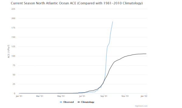
Storms
lasting for so long and hitting such high intensity produce a lot of
energy. And the primary measure we have for that expended energy is
ACE or Accumulated Cyclone Energy. 2017 is bound to achieve one of
the highest ACE measures for any Atlantic Hurricane Season. Since
1851, only 8 years have seen an ACE value hit above 200. Present 2017
ACE is at 194 and climbing. Highest ever ACE values were recorded in
2005, at 250, and 1933 at 259.
Individual
storm ACE values are also impressive with 2017 presently showing 3
storms with an individual ACE higher than 40. Only
27 storms with a 40+ ACE value are ever recorded to have formed in
the Atlantic.
Irma, so far, is the highest ACE for 2017 at 66.6 — which is the
second highest individual storm ACE ever for the Atlantic. Jose
produced an ACE of 42.2 (24th) and Maria an ACE of 41.4 (26h).
If
2017 continues to produce strong, long-lasting storms over a record
hot Atlantic, it is easily within striking distance of a record ACE
year. The restrengthening of Lee to major hurricane status so far
north and out in the Atlantic was yet one more surprise that shows
how much energy the Atlantic is bleeding off this year. Such a
tendency will likely continue through October but with storms
probably not forming quite so frequently as during September and
originating in regions closer to the Caribbean and U.S.
Links:
Hat
tip to Suzanne
Hat
tip to Vic
Hat
tip to Umbrios
No comments:
Post a Comment
Note: only a member of this blog may post a comment.